Expansion Map
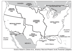 Expansion Map
Growth of the United States from the original 13 states to 1853.
Growth of the United States: Original Thirteen Colonies, Treaty of Paris 1783, Louisiana Purchase 1803, Adams-Onis Treaty 1810 & 1812 (annexed), land ceded by Great Britain 1818, land ceded by Spain 1819, readjustments in the Webster-Ashburton Treaty 1842, Texas Annexation 1845, Oregon Territory 1846, Mexican Cession 1848, Gadsden Purchase 1853, Alaska Territory 1867, Hawaii 1898.
Growth of the United States: Original Thirteen Colonies, Treaty of Paris 1783, Louisiana Purchase 1803, Adams-Onis Treaty 1810 & 1812 (annexed), land ceded by Great Britain 1818, land ceded by Spain 1819, readjustments in the Webster-Ashburton Treaty 1842, Texas Annexation 1845, Oregon Territory 1846, Mexican Cession 1848, Gadsden Purchase 1853, Alaska Territory 1867, Hawaii 1898.
Five Regions of the United States
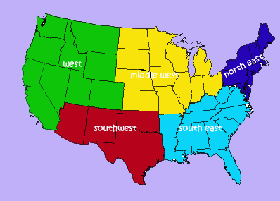
Depending on the source these regional divisions may vary.
Regions: Northeast (Maine, New Hampshire, Vermont, Rhode Island, Connecticut, Massachusetts, New York, Pennsylvania, New Jersey, Maryland, Delaware); Southeast (Florida, Georgia, South Carolina, North Carolina, Virginia, West Virginia, Kentucky, Tennessee, Arkansas, Mississippi, Alabama, Louisiana): Midwest (Ohio, Michigan, Missouri, Indiana, Illinois, Wisconsin, Iowa, North Dakota, South Dakota, Nebraska, Kansas, Minnesota); Southwest (Texas, Oklahoma, New Mexico, Arizona); West (California, Oregon, Washington, Colorado, Wyoming, Idaho, Montana, Utah, Nevada).
Regions: Northeast (Maine, New Hampshire, Vermont, Rhode Island, Connecticut, Massachusetts, New York, Pennsylvania, New Jersey, Maryland, Delaware); Southeast (Florida, Georgia, South Carolina, North Carolina, Virginia, West Virginia, Kentucky, Tennessee, Arkansas, Mississippi, Alabama, Louisiana): Midwest (Ohio, Michigan, Missouri, Indiana, Illinois, Wisconsin, Iowa, North Dakota, South Dakota, Nebraska, Kansas, Minnesota); Southwest (Texas, Oklahoma, New Mexico, Arizona); West (California, Oregon, Washington, Colorado, Wyoming, Idaho, Montana, Utah, Nevada).
U.S. Geographical Map
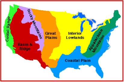
The major geographic regions in the United States.
Coastal Range, Basin and Ridge, Rocky Mountains, Great Plains, Interior Lowlands, Appalachian Mountains, Coastal Plain.
Coastal Range, Basin and Ridge, Rocky Mountains, Great Plains, Interior Lowlands, Appalachian Mountains, Coastal Plain.
U.S. Physical Features
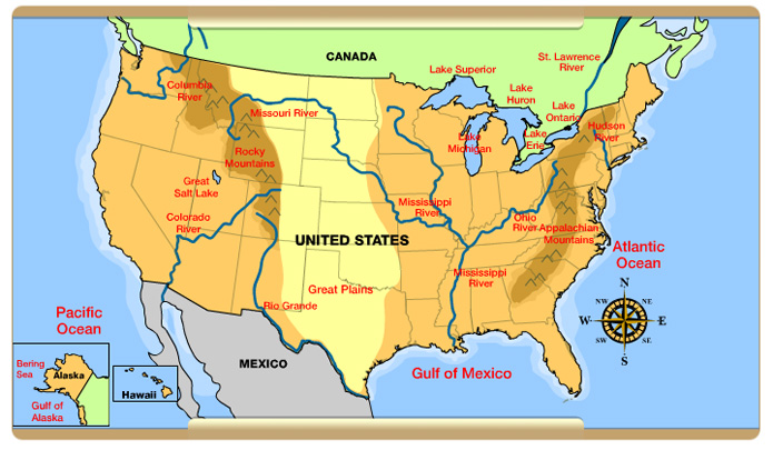
Physical: Mississippi River, Missouri River, Colorado River, Rio Grande, Appalachian Mountains, Rocky Mountains, Sierra Nevada, Coastal Plains, Great Plains, Interior Lowlands, Coastal Range, and Basin and Ridge, Great Lakes (Superior, Huron, Michigan, Erie, Ontario), Death Valley, Grand Canyon, Mt. McKinley.
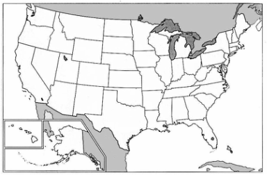
Blank Political Map of the United States